12-Oct-2024
Reconstruction
of the AONB
Plans are currently being laid for the reconstruction of the AONB, as the main contractors finish the civils phase of construction. There is a marked absence of any overall coordination or vision, or any attempt at engagement with the communities who will live with the results. This presentation gives a short outline of the current unsatisfactory situation.
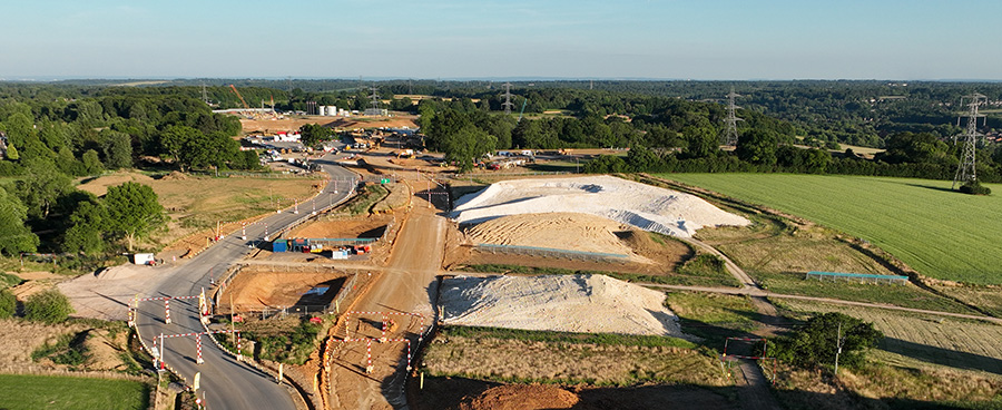
View towards the N. Portal; footpath GMI/2 crosses in the foreground
History
The HS2 route through the AONB lies within "Community Forum Areas" (CFAs) 9 & 10. An initial assessment of the expected damage was made in the Environmental Statement (now located here); it was widely criticised as inadequate when released.
During the passage of the hybrid bill, an undertaking was made that the AONB review group would be established, to develop design principles for the AONB. The review group produced a report - Detailed Design Principles - in Nov 2017. This was the first (and only ?) overview of design and construction in the AONB as a whole; however, it mainly made recommendations about the physical structures to be constructed. "Vegetation outside of Operational Limits" was covered in two pages (here) - despite "This component offers possibly the greatest means of accelerating the integration of the line" with the AONB. The DDP report considered the integration of HS2 into the Bucks Landscape Character areas - namely, undulating plateau (15.1) and upper chalk river valley (13.5 - "The valley retains a tranquil, unspoilt and ‘rural’ character..." ). It is not clear to what extent this aim is informing the current proposals.
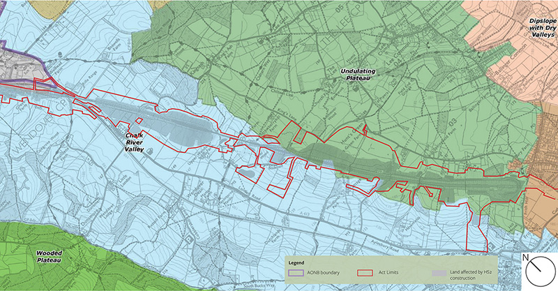
Landscape Character Areas (from DDP section 2.1)
Biodiversity
While the review board were considering details of the design, HS2 were surveying the biodiversity along the route, and in 2017 released a report claiming 'No Net Loss' (of biodiversity). The GIS data to support this claim was released in 2021, which identified the type of landscape (at the level of individual fields and hedgerows) before and after construction. This data was analysed by the Wildlife Trusts ("Double Jeopardy") who concluded that
"the HS2 No Net Loss figures released in 2017, in 2019 and in 2021 are wholly unreliable. These are based upon poor quality data riddled with inaccuracies and rely on an untested assessment methodology that is subject to little independent scrutiny and no independent quality assurance"
The Wildlife Trust's report covered the entire route, and contained few examples, so the Chiltern Society undertook a detailed examination of the biodiversity calculations in the AONB, using material gathered since the project was first proposed. This report confirmed many of the failings noted by the Wildlife Trusts, and also found that
- Not all new or restored habitat was correctly identified, so in fact 75% of the area will require restoration, rather that the 40% explicitly identified as new planting.
- While HS2 claim a 10% increase in overall diversity, this actually requires an 80% increase over 10 years (due to the discounting of future enhancements required by the metric).
It is not clear how this significant increase in biodiversity can be achieved, if the new habitats are to retain the characteristics of the existing LCAs. Nor is it clear whether the Schedule 17 applications currently submitted still aim to generate this improvement.
Mitigation and Restoration Planting
The landscaping plans currently presented require planting of everything from wildflower meadows to woodlands. To succeed, the right stock must be selected, and planted at the right time of year, to have the best chance of survival, and appropriate care must be provided for several years, where necessary. Deer and grey squirrels are a particular hazard for new woodland planting in the Chilterns.
The state of the advanced mitigation planting beside Bowood Lane does not inspire any confidence in the ability of HS2 to co-ordinate these operations.
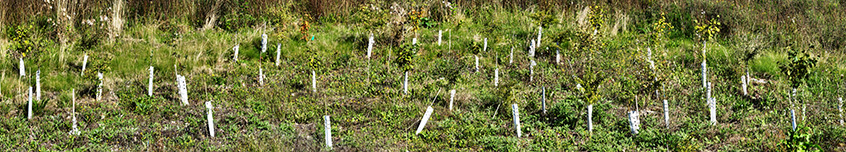
Advanced planting off Bowood Lane - Oct-23
Local councillors have made repeated requests to HS2 that the condition of this planting should be revealed, so that the steps necessary to ensure its survival can be debated, but no engagement has taken place. This is unacceptable; local representatives should receive a report on the state of planting in their area, at least annually, and have a clear channel to communicate any concerns as they arise.
'Left over' land
It is now clear that some packages on non-operational land are unlikely to return to their original use (mainly farming), due to fragmentation of fields, or restricted access. Such land will be managed by the nominated undertaker, until some alternative arrangement can be put in place (Information paper E16, para 2.7). It is time to make an initial assessment of how many plots of land may be in this category, and to devise a management strategy, if this seems necessary.
S17 applications
This Map shows the boundaries of the main S17 applications in the AONB ( Work in Progress ! Best downloaded, it is large)